Sunday, December 13, 2009

Holiday Bike Drive

Since the beginning of September I have been volunteering at the Community Cycling Center. They have been gearing up for their annual Holiday Bike Drive. This is a huge event where they provide over 500 children with their first bike, a bike helmet, and basic safety instruction. It is designed to benefit ages 3 - 8 from low income families. Children are referred to the Holiday Bike Drive by a school, church, or social service agency.


For the most part I was helping refurbish donated bikes. Often I would take the bikes apart and repack the bearings. It was challenging to develop a feeling if a part was not too tight or loose, but just right. The biggest thrill was disassembling a coaster brake, lubing it up, and then putting it back together. I am grateful to those who taught me these skills and encouraged me along the way.


Approaching the sight of the Holiday Bike Drive it was very special to see a kid, helmet on, wheeling their new bike to car. I had not even stepped in the door, but I had already seen how my contribution had made a difference. Inside I found an organized flow of volunteers, parents, and children and all of the bikes lined up. Outside I saw volunteers braving the cold to teach some basic biking skills. I was tasked with fitting kids with a bike helmet. All of them were very patient with me as I adjusted and readjusted the straps of their helmets. Those kids were not the only ones who benefited as I went home and corrected the adjustment of my own helmet.


Saturday, November 14, 2009

Cape Horn

Rarely when one goes on a major hike in the Columbia River Gorge do they hike between the freeway and the river. Today I did just that as I led an Adventurous Young Mazamas hike on the Cape Horn trail. This was my third attempt in the past 12 months to led this hike. High winds and snow foiled my plans the last two times. But today the weather was cooperative and we were able to enjoy the sweeping views of the gorge that this trail offers.

I should note there is much more to this hike than views and waterfalls. I was fortunate to have Mazamas Hike Leader Cathy Oswald along on this hike, as she knows this trail like the back of her hand. She shared what she knew about this trail with us and helped me lead the group.

The Friends of the Columbia Gorge have played a major role in protecting the area from development. They have worked with various individuals and land trusts to acquire properties to protect this stunning view of the gorge. Their video for their Campaign for Cape Horn on YouTube gives some insights of their role.

Currently the Forest Service is working on a Environment Assessment for the Cape Horn Trail Recreation Plan that considers the route of the trail. You can view the Environmental Assessment here. There was some discussion on our hike of the possible alternatives that the Forest Service is considering for this trail.

Saturday, November 7, 2009

Rudolph Spur

Even thought the weather report did not look encouraging, I ventured into the Columbia River Gorge for a hike up Rudolph Spur. This is an unmaintained trail that starts out at Cascade Locks on the Oregon side of the gorge and ascends to the Benson Plateau.


This is a trail that climbs up a forested ridge, which I find very enjoyable. Even though not one among us had set foot here before, most of the time we did not have any route finding problems. We were quite fortunate with the weather since it was dry as we hiked up the steep portions of the trail. It was not until we started to reach the Benson Plateau that it started to snow.


Our descend was via the Ruckle Creek Trail. At we lost altitude the snow turned into pouring rain. The trail was steep and slippery, so I took care to place my feet well. At one point I heard a thunderous snap to the left of me. As I looked in that direction I saw the upper trunk of a dead tree tumble down to the ground. Glad to be a at safe distance, I continued my way to the trailhead and the dry cars.

Saturday, October 31, 2009

Halloween 2009


Although I am well beyond my trick or treating days, I celebrated Halloween this year at a variety of venues this year. It started last weekend when Deborah and I checked out the Field of Screams on Sauvie Island. We thought this haunted corn field was more effective than a haunted house. It seemed that the thick corn stalks gave the various monsters better hiding places than the restrictive walls found in a building.

On Friday I left my tie at home and at work as I dressed up as a Lumberjack. I could not help to whistle the tune to Monty Python's Lumberjack song as I shouldered my axe. In my mind's eye I imagined myself leaping from tree to tree as they floated down the mighty rivers of British Columbia.

On Halloween itself we toured the Lone Fir Cemetery in Southeast Portland. As we were led around the cemetery we 'met' several of the inhabitants of this graveyard, who shared with us their stories. This included a woman caught up in a love triangle/double-murder suicide, a business man who shanghaied his own son and a prostitute whose gravestone was paid for by her clients. My neighbor Michael, who helped organize the event, later told me that 2400 people took this tour that evening.

To top it off we watched the film Shaun of the Dead, which was quite amusing. If zombies invade my hometown, I hope I would not be as oblivious to them as the movie's hero. I will confess that I covered my eyes during the really gory part.

Wednesday, October 28, 2009

Day Hiking in the Olympic Peninsula

Most Wednesday evenings October to April the Mazamas presents Evening Travel Programs, which are open to the public. These are usually presentations along hiking, climbing, and travel themes. From time to time I've found they are a good way to spend an rainy Wednesday evening.


This evening Craig Romano was plugging his book Day Hiking Washington's Olympic Peninsula. While it was nostalgic to see slides of familiar places such as Wagonwheel Lake, Shi Shi Beach, and Ozette Lake, I appreciated the chance to learn about lesser know places. Going to this lecture broadened my knowledge of the South Flank of the Olympic Mountains. Also, my friend Scott would have been pleased that the author had photo slides of the Piper's Bellflower, which is endemic to the Olympic Peninsula.

The author defines the Olympic Peninsula as everything from the Strait of Juan de Fuca to the Columbia River. So he also presented a handful of lesser know hikes in Washington State Parks at Long Beach and Ocean Shores.

I asked the author if he thought the National Forest Service would reopen the road along the Dosewallips River. His perception was that the Forest Service wanted to do so and would start once they had cleared any legal challenges.

Sunday, October 18, 2009

Central Oregon Trip

My brother Scott was in Portland for a business trip the past week. At the end of the week we took a trip to Central Oregon, which turned out to be a good diversion from rainy Willamette Valley weather.


We covered a lot of territory on this trip. We hiked up Misery Ridge at Smith Rock State Park and watched climbers on Monkey Face. In Bend we caught up with Jen Floyd, who we worked with at Camp Parsons. We also checked out Cline Falls State Park, home of an unsolved attempted axe murder. On the way home we stopped at Silver Falls State Park to relive some childhood memories.

The big surprise of the trip was the hike along Tumalo Creek. I had heard about this area, but it was my first visit there. Tumalo Falls is located within tripping distance from the parking lot, but this is one of those hikes where continuing down the trail is well worth the extra effort.

Tumalo Falls


Upper Tier of Middle Tumalo Falls

Upper Tumalo Falls

Saturday, October 10, 2009

Robert Marx Memorial Service


This weekend I traveled to Springfield, VA for the memorial service for Bob Marx, my father's cousin. Even though his family lived on the East coast, we saw him a handful of times during my youth. I always liked seeing cousin Bob. His easy going demeanor had an encouraging and supportive tone.

I knew that he had a long career at the Census Bureau, but until today I did not know the extent of his professional contribution. He was the architect of the Census Bureau's TIGER Format, which was used to improve the Census Bureau's process of taking the Decennial Census. In fact, Bob was the one who coined the acronym TIGER, which stands for Topologically Integrated Geographic Encoding and Referencing. If you are interested about TIGER, you can read more about it here on Wikipedia.

But this gathering was about much more than Bob's professional achievements. His 4 year old grandson got up in front of the audience to say how he wished that his grandfather would return to to play in his sandbox. I doubt at that moment there was a dry eye in the sanctuary. For me, I grieved that my father had lost his surrogate brother and childhood friend. The occasion also provided the opportunity to reacquaint myself with the Marx side of our family. I also got to meet many relatives that I had never met before.

Sunday, September 27, 2009

Port Townsend

It has been a long time since I have visited the seaside town of Port Townsend. Lately the closest that I been there was passing by on Highway 101 on the way to Port Angeles and Olympic National Park. That changed when my girlfriend Deborah participated in West Coast Sea Kayaking Symposium in Port Townsend. Since Port Townsend is only an hour away from Camp Parsons, it was a great opportunity to see her doing something that she loves.

The symposium was held on the beach at Fort Worden State Park. Scenes of An Officer and A Gentleman, mostly filmed in Port Townsend, were rolling through my mind as I arrived. It was a glorious day to be out on the beach. In the distance I saw the gun embankments of Battery Kinzhe. It was here that fellow Parsons staffers and I had played games during one of our weekends off. At the Symposium there was a large selection of vendor booths selling various wares. There were dozens of kayers out in the water, including Deborah taking an Advanced Rescue class.

Later I hiked up to Artillery Hill to explore some of the other batteries. I cautiously walked thought the dark corridors of the fortifications, just like I did as a boy. At Battery Quarles I found a scenic lunch spot. Across Admiralty Inlet was Whibey Island and Ebby's Landing, a place that I have hiked with friends and family. Further in the distance was Mount Baker, reminding me of my visit there last summer. I was also eying Mt Shuksan.


Whenever I visit the Olympic Peninsula, I am always looking inland for glimpses of the mountains that are dear to me. While I suspect that always will be the case, today I benefited from someone giving me a good reason to shift my focus somewhat.

Saturday, September 26, 2009

Silver Marmot Grill

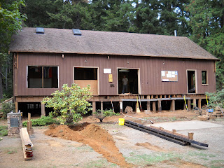
Saturday I volunteered at the monthly maintenance party at Camp Parsons and ended up tearing things apart. This time it was the porch of the Silver Marmot Grill, a building that is 90 years old.

Actually it was the backhoe that was responsible for most of the destruction, I just had to clean up after all of the carnage. With the porch removed, I as able to see the original structure and how they had renovated upon that in the 1960s. We could also see where some of the original beams had been removed and replaced about 12 years ago where part of the structure had rotted.


Even more shocking was to see the inside of the building after it had been gutted out. The small office where I had spent two summers as the Business Manager is gone. The plan is to move the Trading Post into the Program Office, making more room from offices and a meeting room.

Sunday, September 13, 2009

Old Snowy

I hardly expected that I would be changing a flat tire just before my first climb as a full fledged Mazamas Climb Leader, but there I was underneath a car positioning a tire jack. We were camping at the Berrypatch Trailhead, preparing to hike into the Goat Rocks Wilderness and climb Old Snowy. This location was an alternate one since we discovered that Chambers Lake campground was full. It was after getting everyone together that one person noticed that the flat tire.

The rest of the climb went much smoother. The Assistant Climb Leader George Cummings was invaluable as he helped others ascend the crux of the climb. The weather was ideal and the views of Rainier and Adams were stellar. As a bonus there were blue huckleberries to eat and fat marmots to photograph.


As for flat tires, we were not the only Mazamas with that challenge this weekend. The Assistant Climb Leader of the Washington Ellinor Traverse return to the trailhead to find that she had a flat tire as well. It was an amazing coincidence.

Sunday, August 30, 2009

Yosemite National Park


Ever since my acceptance into the Mazamas Advanced Rock class, I had been looking forward to their trip down to Yosemite National Park. While I had no plans of big wall climbing in this cathedral of rock climbing, I relished the chance to practice my newly learned trad lead climbing skills on the world famous granite.

Then in July I stumbled and landed on my left thumb. The injury was not serious, but damaging enough to curtail my climbing plans. So instead I planned to climb with my feet and explore by hiking and backpacking.

Our class set up base camp at a campground overlooking Saddlebag Lake on a pass at an elevation of 10000 feet. For you Oregonians out there, that is like camping at the base of Mt. Hood's crater. Even though it was just outside of Yosemite's Tioga Pass entrance, it offered more peace than the car camping options inside the national park in a beautiful alpine setting.


While my colleagues were out climbing, I took a handful of hikes. My first was was to the top of Mount Hoffman, near the geographic center of the park. I also took a short hike amongst the Giant Sequoias in the Tuolumne Grove. Then went down to Yosemite Valley and braved the crowds and explored some of the meadows. On the way out of the valley I stopped at Tunnel View and understood why this place is known as the 'Incomprehensible Valley'.

The highlight of the trip was three day backpacking trip from Tuolumne Meadows down to Yosemite Valley. Monday morning I was dropped off near the Tuolumne Meadows Lodge, elevation 8600 feet. With my wilderness permit and bear canister loaded in my backpack, I headed down the Muir trail and then headed south along Rafferty Creek. After gradually gaining altitude I found myself at the Vogelsang High Serria Camp. As I ate lunch at Fletcher Lake I soaked in this glorious high alpine setting. It got even better as I hiked past Vogelsang Lake and then up to Vogelsang Pass (elevation 10600 feet). My breath was taken away as I rounded the corner and saw the water tumbling down the from Gallson Lake. Below me was the Lewis Creek Valley. As I descended down this valley the creek would slide down slabs of granite. In the distance grand granite domes rose above me. My final mile was a pleasant walk through the shaded forest to the backpacker's campground at Merced Lake. Here I found a flush toilet (such a luxury) and friendly companions that invited me to join their campfire.

Tuesday morning I broke camp and followed the Merced River to Echo Valley. At the trail junction I was startled when a cinnamon colored bear crossed my path. It was not that big, so I paused a looked for mama bear. After awhile it appear that this bear was out solo so I pressed onward. Above me I heard the woodpeckers pecking out insects from the bark, a reminder of home. I gained some altitude and soon found myself above the Merced River valley. Here I was looking down into the Lost Valley, dominated by the impressive granite dome of Bunnell Point. I rejoined the John Muir trail and set up camp at a trail jucntion with good water access. I loaded up my fanny pack and started up the trail to Clouds Rest. The view of Half Dome and the Yosemite Valley got better as I rounded each switchback. Then the big surprise of the day, a hiker that was descending the trail recognized my voice. It was Chris Bibro, a fellow Mazama, who was backpacking with his girlfriend. Chris told me the view from Clouds Rest was spectacular and he was not kidding. At 9926 feet elevation, I was looking down on Half Dome and the Yosemite Valley. Not far away I could see Mount Hoffman plus I could make out the route that had brought me here. After lingering at the summit for some time I descended down to my campsite to rest for my day three.


Tuesday morning I broke camp and headed down the John Muir trail to the Half Dome trail junction. I read that bears were active in this area, so I left my backpack behind, separating my stove and bear canister. Gradually the trees thinned out and I found myself at the base of Half Dome's Cable Route. This is the famous final 400 feet via two cables strung between poles that rest in holes drilled in the steep granite face. As I ascended I got into a rhythm with my arms doing most of the work pulling myself up. The time I spent climbing on granite at City of Rocks gave me the confidence to trust that my feet would hold. The view was worth every step of the way. My efforts to get up here early paid off as I did not have to deal with too large of a crowd as I descended. Downclimbing involved communicating with those who were ascending as the space between the cables is too narrow for two people.


Back down at the trail junction I discovered that chipmunks had gotten into my backpack. I found one of my chemical hand warmers 20 feet from the backpack. Better them than bears. I descended down into Yosemite Valley, enjoying the view of Nevada Falls. During this trip I had seen some incredible sights, but none were as welcome as my car waiting for me at the trailhead.

But this was not the last chapter of this backpacking adventure. The Big Meadows fire had broken out in the National Park, closing a critical road for my return to Saddlebag Lake. A drive that should have taken 2 hours lasted 4.5 hours. When I finally made it back to home base all had retired for the night and the last of the campfire embers were fading.

When my time in Yosemite had ended, I drove north to Truckee to visit my cousin Eric and his family. We had a wonderful picnic dinner at Donner Lake and then later I got to read bedtime stories to his girls. The next morning I packed up one last time and drove home.

You can see more photos at this link.

Sunday, August 16, 2009

Neahkahnie Mountain

While I would prefer to be in the mountains than on the beach, my summer would not be complete without a visit to the Oregon Coast.  For some time I have been itching to return to Neahkahnie Mountain, which would give me both my mountain and beach fix.

Our group departed from the Hillsboro area Sunday afternoon, our destination was Oswald West State Park. One member of our group was from Germany and this was his first time seeing the Pacific Ocean.  Seeing numerous surfers headed towards the beach only seemed to add to his excitement.


We paused at the Devils Cauldron to soak in the view of Smugglers Cover and Cape Falcon.  From here the trail started to climb in earnest.  I had forgotten how magnificent the Sikta Spruce trees are along this hike.  In some places they were growing in so close that the sun was blocked out.

The translation of Neahkahnie is place of the gods, which seems a fitting name for this viewpoint.  Looking south towards Nehalem Bay with the surf crashing along the beach is certainly a view fit for the gods.


After a leisurely dinner and dessert on the summit, we descending back to the Short Sand beach.  I was hoping to catch the sunset, but a narrow band of clouds on the horizon had the sun disappearing ahead of schedule.  While we did not witness the sun as it set, we did catch the surfers gliding back to shore.  That was thrilling enough for our German friend.  Welcome to Oregon...


Sunday, August 9, 2009

Portland Bridge Pedal

Late Saturday Night I made a last minute decision and registered for the Providence Bridge Pedal.  Less than 10 hours later I joined 18000 cyclists who jumped at the chance to ride their bikes over the bridges of Portland.  It was quite a spectacle.  I saw Portland Mayor Sam Adams handing out bike maps.  I also saw petitioners gathering signatures to get a recall of Mayor Adams on the ballot.


I choose the shorter route which covered six bridges.  It was a weird feeling to ride down the off ramp and find myself biking on the highway.  The view from the Marquam Bridge, which is part of Interstate 5, was worth the price of admission.

Saturday, August 8, 2009

Olympic Peninsula Trip

Once again the spell of the Olympic Peninsula beckoned and I heeded its call.  This time I drove up to Camp Parsons for their Friday Night Campfire.  The mountains were hidden by a thick layer of clouds as I drove along Highway 101.  I made it just in time for the campfire.  It was so nostalgic to participate in the songs and traditions at camp.  It was even better hanging out with Anne and Anton Kramer and their family.  I even got to eat some of Jack's birthday cake and listen to Monica tell me about her backpacking trip to Lena Lake.  I had such a nice time I forgot my toothbrush there.

Heading back south on Saturday I turned off Highway 101 at Hoodsport and entered Olympic National Park at Staircase.  My plan was to hike up to Wagonwheel Lake.  And just in case one missed this warning about the difficulty of this hike...

...the National Park Service posted a second sign.

Most of the time I hike with groups.  From time to time I need to hike by myself, so I'm not distracted by the conversations or responsibilities.  The way things have been going I needed some solitude to sort out my thoughts.  I needed an opportunity to watch the lichen flutter in the breeze, to observe how wisps of clouds playfully dance in the air, and notice how a Grouse carefully inches down a fallen log.


After reaching the egg shaped Wagonwheel Lake I could not resist checking out an unmaintained trail that led from the lake to a point 700 feet above the lake.  I found the trail, took a compass bearing, and headed upward.  Upon arrival at that point I was treated to a brief view of Saint Peter's Gate, Mt. Washington, Mt. Ellinor, Copper Mountain, and some of the Sawtooth Range.  Then the clouds returned.  It occurred to me that perhaps sometimes we live in the clouds, unable to see the big picture.  Then forces greater than ourselves, on their schedule, clear out the fog and provide a moment of clarity.  That though gave me a sense of peace as I ate my lunch, surrounded by clouds.

Tuesday, July 28, 2009

Middle Sister via the Hayden Glacier


This weekend I returned to the Sisters Wilderness for my fifth climb on Middle Sister, located in the Central Oregon Cascades.  We started at the Pole Creek Trailhead and hiked about 4.5 miles to our base camp near the base of the Hayden Glacier.  It is a grand place to set up camp as Broken Top and the Three Sister formed an arc around us.  Looking West could see our route on the far right of the glacier, that led to a saddle, with Middle Sister on the left and Prouty Point on the right.


All of that was obscured by the cover of darkness when we departed from camp at 4am.  The sky was studded with stars as I led the group up a valley to the foot of the glacier.  As we donned our climbing harnesses and roped up it started to lighten up, revealing the grandeur surrounding us.  The snow was just right, so we did not need to put on our crampons.  At the saddle our two rope teams clipped out of the rope and ascended up the snow free North Ridge.  While it is just a walk up, the loose scree was mentally and physically demanding.  About 9:05 am we were at the fifth highest point in Oregon.


I chose Middle Sister since I climbed here last year in similar conditions.  The big exception was the lack of snow of the North Ridge and the fact that it was my show to lead this time.  I felt fortunate to have good weather and a good team along with me on this climb.  And I did observe signs of teamwork, such as those supporting those who were new to climbing up scree or helping someone remember how to clip through a running belay.  To be part of a functional team is a very meaningful experience to me.


Monday, July 20, 2009

Hop to it Kangaroos! High School 20th Reunion


The day I knew would be coming finally came, the 20th anniversary of my high school graduating class.  I had enjoyed the 10 year reunion, so it was a no-brainer to attend this one.  I departed Portland Friday evening at got to Bellevue, WA  just in time for the class photos and dinner.


In some ways it was overwhelming to walk into the hotel reception room.  There were so many familiar faces, but do I really know any of these people?  Then I started to talk to people, some of which I had gone to school with since my elementary school days.  I started to feel at home again.  It was also fun to catch up with one of the Music Hall gang, the group that I so identified with during high school.


Saturday morning I went to part two of the reunion, a picnic at Marymore Park in Redmond.  There was a smaller crowd than at the reception, but it afforded me the chance to talk with those who were outside of my social circle.  We even got some musical entertainment, since the picnic took place right next to the concert area.  Death Cab for Cutie was warming up for this evening, so we got a preview of the show.


There was also a reminder that our graduating class is not immune from the fraility of life.  At the reception there were photos of those from our class that have passed away.  One was David Johns, who earned his Arrow of Light in Cub Scouts along with me.  It was a reminder life was meant to be lived.

Sunday, July 12, 2009

Mt. Stone

For my second Provisional Climb lead I chose Mt. Stone, which is a double peaked mountain located in the Olympic Mountains near the Hamma Hamma River.  I had been here four years ago and felt it would be an appropriate place for me to lead a climb.  This would be a step up from leading up the trail on Mt Ellinor as Mt Stone has a handful of places where we would be off trail and scrambling up rocks.


After scheduling the climb I learned that there was a washout across the road 2.5 miles before the trailhead.  So when we discovered that the road had been fixed, our climb got off to a great start.  And it continued to get better as the weather was good and the wildflowers were spectacular.  A major route finding challenge was solved when we figured out where to go once we got to the Pond of the False Prophet.


For me it was a treat to see how much my rock climbing had  improved since my last visit here.  I was amazed at the great hand and foot holds that I was finding.

Our climb did have a scary moment when one person fell and took a tumble.  Fortunately that person was OK and  able to continue down.  It was a reminder to me of some of the fine points of accident management and first aid.

Thanks to Doug Briedwell for the second photo. 


Sunday, July 5, 2009

July Garden Report

This morning I was tending my garden.  The backyard is on the North side of the house, it is a very cool, pleasant place to be in the morning.  I find it kind of peaceful to be back here, looking over the plants and checking on their progress.  Well, there are little interruptions in my tranquility whenever I see aphids and cabbageworms.  Then again, gardening is like life, it throws curveballs and aphids your direction.  Things do fall into place, even if the cabbageworm nibbles on the Kohlrabbi.

I am starting to see Zucchini growing and really have enjoyed the flowers that this plant has bloomed.  It was fascinating to see that this flower closed when the temperature got hot and then opened up again once it had cooled down.


While I have had a stead diet of leafy greens, I am starting to get broccoli as well.  It has been a regular ritual to step outside with my basket and scissors and clip something off for dinner or lunch.


Friday, July 3, 2009

Trapper Creek Wilderness

For some time I have wanted to hike in the Trapper Creek Wilderness, which is located in the Southern Cascades and is part of Gifford Pinchot National Forest.  While I did trail maintenance in this area last year, I have not hiked up to Observation Peak.   So when the question of what to do with my day off on July 3rd came up, scheduling a hike there seemed like the natural answer.  As I planed the hike, I decided to follow the grand tour suggested by Paul Gerald's 60 Hikes Within 60 Miles of Portland.  With the three day weekend I figured I could dedicate the whole day this 13 mile loop along the Trapper Creek Trail, up to Observation Peak, and then returning via the Observation Trail. 


Most of this hike was under tree cover, which was ideal for a day where the temperature got into the 90s.  The first 4.5 miles did not have any serious elevation gain, but then it took off in a hurry.  And we were not following the trails that the author described as 'a butt-kicking good time' that the Mazamas built and maintained.  At one point we crossed over some patches of snow patches and then the mosquitoes came out in force.  I had smashed bugs smeared all over my legs and arms.  But then their numbers dwindled and we made the final push for Observation Peak.  Up there the Bear Grass was blooming and we had a stellar view of the forested valleys, the local volcanoes, and a couple of familiar high points in the Columbia Gorge.

I really have to hand it to the four who signed up to join me.  This was a long, demanding hike on a hot day.  However we all worked hard and I am certain it was worth the effort.  One gal was preparing for an upcoming Mt. Adams climb.  It felt meaningful to me to help her towards that goal.  It also felt good to prepare myself for my upcoming climbs in addition to enjoying a great day in the outdoors.