Showing posts with label Hiking. Show all posts

Saturday, September 17, 2011

Dolomites Roller Coaster Afternote: Spain

With the completion of my trek through the Dolomites I caught a series of buses and trains, arriving in Milan late at night. After a good nights rest I boarded a bus that took me to the airport. It was time to say ciao to Italy and hola to Spain. Here I spent three days with my sister and her family. I was touched to learn that one of my nephews made sure that my room was neat and tidy for my arrival, going as far to write a sign telling his younger brother not to mess up the bed.


After eight days of demanding hiking it was nice to rest, play in the neighborhood pool and goof off with my nephews. Tanya and I also took the commuter rail into downtown Madrid and visited the the Museo Sorolla. This was the home of the painter Joaquin Sorolla and housing many of his paintings. I was impressed by how well he incorporated light in his landscape and beach paintings. The museum did a nice job showing the different phases of his paintings and had a wonderful garden outside.


Tanya also introduced me to the Parque Europa. This is a park across the street from her home that has replicas of many famous European landmarks. In one afternoon I was able to crane my neck looking up the Eiffel Tower, pass through the Brandenburg Gate and cross London's Tower Bridge.

For my final full day in Spain we had a road trip, braving the heat we checked out the ruins of a castle at Zorita de Canes. Before storming the castle I helped my nephews find crawdads at the picnic area. It is very refreshing to see two young boys so excited about the birds and animals in the natural world.


The plunder from storming the castle was cupcakes, mostly to celebrate the birthday of my nephew. The chance to be present so close to his birthday was a gift to me, rarely do I have that chance.

After the cupcakes were digested and the gifts were opened it was time to rest. For the next morning I returned to the airport, checked in my backpack and started back home.

Tuesday, September 13, 2011

Dolomites Roller Coaster

Having successfully made it to Ortisei I was ready to begin my journey into the Dolomites. I boarded a two stage cable car that whisked me up to the Secada at an elevation of 2500 meters. From here I headed East.

One of the major draws of hiking in this area was the propsect of spending the nights in high alpine huts, known as rifugios in Italian. Here one could enjoy a beer after a day of hiking, eat a delicious and filling meal and then spend the night without having to leave the alpine environment. All of this was possible without having to carry a sleeping bag, cooking gear and a tent. Before I left I had called ahead and made reservations as I was hiking on the tail end of the high season. Having spent the night in six huts I discovered that each one its own flavor.

I spent my first night in Rufugio Puez. Situated in a tiny little gulley Puez offered good views of the Stella group to the South. The word that best described this hut in my mind is compact. Able to accommodate 94 people, the bunks were three levels high. The low ceilings and archways in the dining area gave the interior a cozy feeling. I spent the afternoon and evening hanging out with a nice couple of Bonn playing cards.


I did not spend my second night at a Rifugio, rather my path dropped down into the resort town of La Villa. Here I spent the night in a pension with a room big enough to dance. Knowing that I had a long day ahead of me I cleaned up and rested. From my porch I had a picturesque view of green pastures and the high peaks.


My next destination was Rifugio Lavarella. Here I was glad that I had made a reservation as this hut was full and turning people away. Located in a flat basin near a pleasant green lake, this hut was modern and positively luxurious. Like uez dinner was ala carte, but unlike my last rifugio I was assigned to a table by myself for dinner.


Located in a unforgettable lunar environment the Rifugio Biella had a more remote, undeveloped feeling. From my bunk room I had an incredible view of the alpine scenery. Downstairs in the dining area I was seated at a table with others. This, along with the smaller dining area, felt more interactive to me which made the evening very pleasant. Biella is located at the base of mountain Croda del Becco, which was well worth the effort to ascend.


After day five I rested my head at Rifugio Vallandro. This hut is at the Southeast end of the wide meadows of Prato Piazza. This hut had a nice wood paneled dining area, comfortable bunks and a little history. It is situated right next to the ruins of an Austrian fort from World War One. From this hut we got up with sunrise and were treated to vivid red colors on the face of the Croda Rossa.


The travel itinerary that I was following suggested spending the next night at Hotel Tre Cime, but we pushed on further to Rifugio Locatelli. What this hut lacked in ambiance it made up in location. It offers an amazming vantage point to appreciate the Tri Cime Lavredo, three distintive peaks that used to be on the border between Italy and the Austrian-Hungarian Empire. I had a delightful dinner here, especially since a couple of Corvallis, Oregon were seated right next to me.


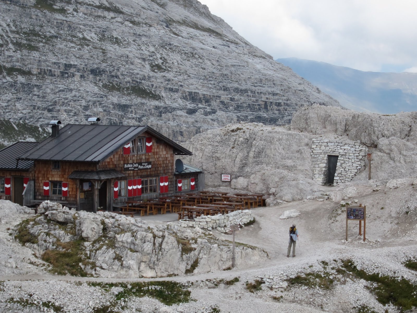
Little did I know that the best rifugio would be saved for last. I spent my final night at the Rifugio Pian di Cengia. Located near the impressive Croda dei Toni peak, this tiny little hut is the highest hut in the Tre Cime Natural Park. After eating my Weiner Schnitzel in the intimate dining area I climbed up a ladder and through a trapdoor to access the 15 bunk dorm.


From here I descended for the last time ending up at Hotel Dolomitenhof. There I only had to wait 3 minutes before I boarded the bus that would take me to Sesto. From there a series of trains would take me to Milano for the beginning of the final chapter of my journey.

You can find more of my photos here.

Saturday, August 27, 2011

East Zigzag Mountain


Saturday my friend Edgar ventured to Mount Hood National Forest for a hike. He brought his 7 month old puppy along. It has been some time since I have hiked with a dog and I was reminded of many of the pleasures of doing so. I'm certain she covered twice the mileage that Edgar and I did, plus tested out the water in all of the various stream that we crossed.

It was a brilliant day to be in the outdoors. We started by hiking up to Burnt Lake and then ventured higher to the summit of East Zigzag Mountain. From this one time fire lookout site we were treated to views of Mt Hood, Mt Adams, Mount Rainier and Mt St Helens. It was cloudy south of us so Mt Jefferson was hidden.


The highlight of the outing was a dip in Burnt Lake. The water refreshing, perfect for such a hot day. It certain made the early rise from bed worth the effort.

Sunday, June 5, 2011

Saddle Mountain

In his fine trail guide of the Olympic Mountains the late Robert L Wood notes that the summit of Mt Olympus is "...one of the few points where one can stand and see both the ocean and Mount Rainier." For years I have wondered where those other points may be and I today I confirmed one of them. Ironically, it is a place I have know most of my life, Saddle Mountain in Oregon's Coastal Range.


The plan was to lead a climb up Mount Shasta, but the climb was canceled on account of bad weather and avalanche conditions. I had looked to Middle Sister as an alternative, but lingering winter conditions and a sudden rise in the temperature made avalanche conditions in the Cascades unacceptable as well. So Saturday I tended to my yard and Sunday I laced up my hiking boots.

The lower elevations of the trail were lush with Oxalis and pink bleeding hearts.


On the upper slopes I saw plenty of red paintbrush....


Seep Monkeyflower...


and some others that I could not identify (any help would be gladly taken).


On the summit we were thrilled by a helicopter fly-by thanks to the Coast Guard. Conditions were so good that for the first time I could see Mts. Rainier, the Goat Rock Wilderness Peaks, Adams, St Helens, and Hood. Next time I'll have to see if I can spot Jefferson. Even more significant for me was that I could look across the Columbia River and see the Olympic Mountains!

Also highly recommended a short spur trail just 0.25 miles after the trailhead. This will take you to a viewpoint that has a grand view of the mountain. I also saw good sized snake soaking up the sunshine. I guess we're not the only ones thankful for the improvement in the weather.

Saturday, May 14, 2011

Mazamas Basic Climbing Education Program 2011

Between late April and early May most of my spare time has been focused on leading a group of 10 students through the Mazamas Basic Climbing Education Program (BCEP). It has been 10 days since our final lecture and since then I have been digesting the events of this endeavor. Leading a BCEP group was a very positive thing for me last year. It was such a great experience that in the back of my mind I was wondering if this year would live up to the previous year. I am pleased to report that this was indeed the case.


One of the assistant instructors suggested that we have a team nickname. I thought that was a brilliant idea. After tossing around a variety of ideas our team selected the "Glissade Brigade".


BCEP is an intense and time demanding experience. In a period of seven weeks there are six lectures, six conditioning hikes, an Introduction to Rock Climbing, a snow climbing field session and a rock climbing field session. In addition the Glissade Brigade spent an evening learning knots, another practicing navigation at Portland's Mount Tabor Park, and spent one evening hanging out at the rock gym. We had three weekends where there was a BCEP activity both Saturday and Sunday. I must have packed my backpack countless times.

Basically I followed the same format from the previous year. The biggest change was that we had the Introduction to Rock Climbing at the brand new instructional climbing wall at the Mazamas Mountaineering Center. Our snow climbing field session took place early in the class in the White River Canyon. We could not practice at Timberline as in past years due to avalanche conditions, but we made the best of the situation.


The bulk of the time is spent on conditioning hikes. The aim of these hikes is not just to get into shape for scaling the heights of the mountain peaks but to practice skills related to alpine climbing. As much as possible we would pull out our maps and compass to practice navigation skills. For one hike I put in a fixed line so everyone could practice using their prusik friction knot. We even worked in a rappel on this hike. While hiking the Glissade Brigade learned how to measure snow slopes to appraise avalanche conditions, adjust their gear for the demanding weather, and make decisions on when to continue hiking or turn back. We even followed the Easter Bunny up Dog Mountain!


Speaking of weather, the Glissade Brigade weathered the elements in good fashion. Our first conditioning hike started out with strong rain. We had two weekends where we saw radical shifts in the weather. For our Snow Field Session it was overcast, snowy and windy only to be followed by a beautiful blue sky hiking up the Palmer snow field the next day. Another weekend we had a gorgeous day climbing on rock at Horsethief Butte followed by overcast skies and light rain on Dog and Augsperger Mountains.


Just like last year, I was blessed with a stellar group of assistant instructors. They gave me new ideas that improved the program. It was very rewarding to me to have four of the graduates from last year's BCEP group join me. They provided valuable insights of their experience last year, which was helpful to me. It was also a joy to watch them step up and apply the skills that they learned last year. I also had some experienced assistants that added so much to the program that we offered.


I am very grateful to the assistants and students (now graduates) of the Glissade Brigade. I appreciated the laughs, fellowship, and experiences that we shared. I am thankful for all that we accomplished together. Climb on!

Saturday, September 11, 2010

Marmot Pass

Marmot Pass, which separates the Big Quilcene and Dungeness Rivers, occupies a special place in my heart. It was here that I backpacked with Camp Parsons High Adventure for the first time. Growing up with the skyline of the Olympic Mountains visible from backyard, the Olympics were already in my sight. But it was this outing where my appreciation of this range sunk in even deeper into my skin.


It has been 24 years since I set foot here. There was still ample Indian Paintbrush to color the alpine meadows. As we hiked up Buckhorn Mountain the clouds moved in and out, giving us panoramic views of the mountains that watch over the Dungeness Valley.


The last time I was here most of our group misread the terrain and map, thus heading away from our base camp. We realized our error in good time, allowing us to return to camp and learn from the experience. This time there were not any navigation errors. Only fond memories of the beginning of the path started here.


Monday, September 6, 2010

Round the Mountain: Different Views of Mt Hood

I spent the Labor Day weekend hiking (not backpacking) most of the way around Mount Hood. During each day of the holiday weekend I hiked a 14 mile segment of the Timberline Trail. Day One was from Ramona Falls to Timberline, Day Two from Timberline to Cloud Cap Inn, and Day Three was from Elk Grove to Top Spur. Thanks to the Mazamas I was able to spend the night at their lodge with a hot shower, hot meal, and a roof over my head.

Here is our route.

I gained a better appreciation of the geography of the area surrounding Mt Hood. I also got to see how the landscape varied. Here are some different perspectives of Oregon's highest mountain.

From the Southwest: Paradise Park


From the South: Timberline


From the Southeast: The Newton Clark Glacier from Laberson Butte


South View: Cooper Spur


Northest View: From Cairn Basin


Mmmmm....Huckleberries.

Saturday, June 5, 2010

Hunchback Mountain

The parking lot at Gateway Transit Center was mobbed with hikers. After enduring a long spell of rain, it was not surprising to find so many people at this central gathering place of hiking groups. Today was going to be sunny to be followed by rain on Sunday. I could sense the deep frustration with the past weather and the excitement/desire to get out now while the weather was good.

There were two dozen hikers that wanted to go Hunchback Mountain with the Mazamas. Since this hike was in a Wilderness Area, our group had to be limited to 12 people. So I joined an unofficial splinter group that hiked independently from the official group.

The trail starts out steep through the lush green undergrowth dominated by Oxalis and Sword Ferns. After the first two miles the trail levels out and most of it is along a forested ridge with a few openings that afforded viewpoints of the Salmon River Valley. There were a couple of times when I had the trees to myself and could absorb the (near) quietness of the forest. I also enjoyed how the trail varied from hiking along steep hillsides and narrow ridges. At the Great Pyramid, a narrow rock ridge that juts out above the Salmon River Valley, we escaped the red ants and found a sunny viewpoint to enjoy our lunch.

Sunday, February 28, 2010

Elevator Shaft


Now, how could you not like a hike called the Elevator Shaft? True, it does not have near the elevation gain as Mailbox Peak near Snoqualmie Pass, but this unmaintained trail in the Columbia River Gorge is sporty. The trail, if you would call it that, makes it way up a talus field, often disappearing.

Along the way my trusty companions and I stopped by the Trails Club of Oregon's lodge. As we passed by the door opened and we were welcomed inside and give a short tour.


It has been four years since I've hiked here. Since I plan on leading this hike in April, I wanted to scout it out, as the maze of trails up above can be confusing. Thankfully we were able to navigate past the Christmas Tree Ornaments (I kid you not) and find out way back to the main trail, which passes by Multnomah Falls. It was good to see the crowds out to see this popular Oregon attraction on such a brilliant day.

Saturday, November 14, 2009

Cape Horn

Rarely when one goes on a major hike in the Columbia River Gorge do they hike between the freeway and the river. Today I did just that as I led an Adventurous Young Mazamas hike on the Cape Horn trail. This was my third attempt in the past 12 months to led this hike. High winds and snow foiled my plans the last two times. But today the weather was cooperative and we were able to enjoy the sweeping views of the gorge that this trail offers.

I should note there is much more to this hike than views and waterfalls. I was fortunate to have Mazamas Hike Leader Cathy Oswald along on this hike, as she knows this trail like the back of her hand. She shared what she knew about this trail with us and helped me lead the group.

The Friends of the Columbia Gorge have played a major role in protecting the area from development. They have worked with various individuals and land trusts to acquire properties to protect this stunning view of the gorge. Their video for their Campaign for Cape Horn on YouTube gives some insights of their role.

Currently the Forest Service is working on a Environment Assessment for the Cape Horn Trail Recreation Plan that considers the route of the trail. You can view the Environmental Assessment here. There was some discussion on our hike of the possible alternatives that the Forest Service is considering for this trail.

Saturday, November 7, 2009

Rudolph Spur

Even thought the weather report did not look encouraging, I ventured into the Columbia River Gorge for a hike up Rudolph Spur. This is an unmaintained trail that starts out at Cascade Locks on the Oregon side of the gorge and ascends to the Benson Plateau.


This is a trail that climbs up a forested ridge, which I find very enjoyable. Even though not one among us had set foot here before, most of the time we did not have any route finding problems. We were quite fortunate with the weather since it was dry as we hiked up the steep portions of the trail. It was not until we started to reach the Benson Plateau that it started to snow.


Our descend was via the Ruckle Creek Trail. At we lost altitude the snow turned into pouring rain. The trail was steep and slippery, so I took care to place my feet well. At one point I heard a thunderous snap to the left of me. As I looked in that direction I saw the upper trunk of a dead tree tumble down to the ground. Glad to be a at safe distance, I continued my way to the trailhead and the dry cars.

Wednesday, October 28, 2009

Day Hiking in the Olympic Peninsula

Most Wednesday evenings October to April the Mazamas presents Evening Travel Programs, which are open to the public. These are usually presentations along hiking, climbing, and travel themes. From time to time I've found they are a good way to spend an rainy Wednesday evening.


This evening Craig Romano was plugging his book Day Hiking Washington's Olympic Peninsula. While it was nostalgic to see slides of familiar places such as Wagonwheel Lake, Shi Shi Beach, and Ozette Lake, I appreciated the chance to learn about lesser know places. Going to this lecture broadened my knowledge of the South Flank of the Olympic Mountains. Also, my friend Scott would have been pleased that the author had photo slides of the Piper's Bellflower, which is endemic to the Olympic Peninsula.

The author defines the Olympic Peninsula as everything from the Strait of Juan de Fuca to the Columbia River. So he also presented a handful of lesser know hikes in Washington State Parks at Long Beach and Ocean Shores.

I asked the author if he thought the National Forest Service would reopen the road along the Dosewallips River. His perception was that the Forest Service wanted to do so and would start once they had cleared any legal challenges.

Sunday, October 18, 2009

Central Oregon Trip

My brother Scott was in Portland for a business trip the past week. At the end of the week we took a trip to Central Oregon, which turned out to be a good diversion from rainy Willamette Valley weather.


We covered a lot of territory on this trip. We hiked up Misery Ridge at Smith Rock State Park and watched climbers on Monkey Face. In Bend we caught up with Jen Floyd, who we worked with at Camp Parsons. We also checked out Cline Falls State Park, home of an unsolved attempted axe murder. On the way home we stopped at Silver Falls State Park to relive some childhood memories.

The big surprise of the trip was the hike along Tumalo Creek. I had heard about this area, but it was my first visit there. Tumalo Falls is located within tripping distance from the parking lot, but this is one of those hikes where continuing down the trail is well worth the extra effort.

Tumalo Falls


Upper Tier of Middle Tumalo Falls

Upper Tumalo Falls